Page 5 of 16
Re: Bildgåta
Posted: 17 May 2022 18:38
by Risberg
marea baltica wrote: ↑17 May 2022 00:34
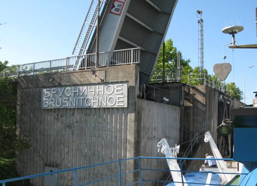
“Ser ut som Rysland (river boats, vegetation, glass frames), but it’s too neat and clean,” was the first impression of seeing the picture.

But there exists a canal that fits to both conditions: Saimaa canal between Saimaa lake and Vyborg. Situated in Karelia, built during the 19th century Tzar times, rented in full length by Finland and widened during Soviet Union times.
The picture seems to be taken in the Särkijärvi/Iskrovka lock, looking towards the east. Perhaps during early 90’s (or late 80’s)?
There’s a pretty cool video of travelling the canal (the lock in the picture is at 0:33 of the total 1min:38sec video length):
https://vayla.fi/en/transport-network/w ... imaa-canal
Det är därför jag godkänner tre alternativ för land; Finland, för att de driver kanalen som en inrikes kanal siden 1967, Ryssland, för där ligger slussen nu, og Sovjet, för det var det när bilden togs 1991. Men slussen är
Brusnitsjnoje.
Re: Bildgåta
Posted: 18 May 2022 23:19
by marea baltica
Risberg wrote: ↑17 May 2022 18:38
/---/ Men slussen är
Brusnitsjnoje.
With all due respect, here I would have to make a correction.

Brusnitsjnoje as the first lock when travelling from Vyborg is lower: the under-bridge clearance height is 8,5m as seen in the picture below. In addition, the view would be different since the quay starts already from the lock and the background water area is wider:
https://goo.gl/maps/oHL1wmviFcg4dJRL6
Therefore it has to still be Iskrovka lock, which is the second from Vyborg: under-bridge height sign is 10,2m as shown on the bridge. I now found that the clearance heights are actually brought here:
https://fi.m.wikipedia.org/wiki/Saimaan ... vat_sillat
And also, Iskrovka lock has some distance of forested coast between the lock and the quay (with two riverboats), which was the main clue at first:
https://goo.gl/maps/VR8X7qx5FVWhcoPZ6
Brusnitsjnoje lock slightly lower:
- 003EC060-DB91-451A-AA58-FE436EC9CEB1.jpeg (48.12 KiB) Viewed 1856 times
Re: Bildgåta
Posted: 19 May 2022 07:43
by Risberg
marea baltica wrote: ↑18 May 2022 23:19
Risberg wrote: ↑17 May 2022 18:38
/---/ Men slussen är
Brusnitsjnoje.
With all due respect, here I would have to make a correction.
Brusnitsjnoje as the first lock when travelling from Vyborg is lower: the under-bridge clearance height is 8,5m as seen in the picture below. In addition, the view would be different since the quay starts already from the lock and the background water area is wider:
https://goo.gl/maps/oHL1wmviFcg4dJRL6
Therefore it has to still be Iskrovka lock, which is the second from Vyborg: under-bridge height sign is 10,2m as shown on the bridge. I now found that the clearance heights are actually brought here:
https://fi.m.wikipedia.org/wiki/Saimaan ... vat_sillat
And also, Iskrovka lock has some distance of forested coast between the lock and the quay (with two riverboats), which was the main clue at first:
https://goo.gl/maps/VR8X7qx5FVWhcoPZ6
Brusnitsjnoje lock slightly lower:
003EC060-DB91-451A-AA58-FE436EC9CEB1.jpeg
With equal due respect: I know what I have taken pictures of, I always cataloged my pictures immediatly when I got them developed and framed and of course in my note book when I took them.
The three pictures just before the one in
Bildgåta 8:


Iskrovka I didn't take any picture of Brusnitsjnoje doesn't show how low or high it ist, as we don't see the water.
Your last picture of
Re: Bildgåta
Posted: 19 May 2022 08:05
by Risberg
FAN! Den dj-a markören hoppar. Ssta texten skall naturligtvis vara:
Iskrovka I didn't take any picture of. Your last picture of Brusnitsjnoje doesn't show how low or high it ist, as we don't see the water.
Dennis, det är faktiskt litet problematiskt att man har så begränsad tid til att rätta upp fel. I de flesta forum är den "evig"!
Re: Bildgåta
Posted: 19 May 2022 14:44
by marea baltica
The two locks under question are very nearby in distance and time and could pretty much consider as the same system. And I had real difficulties differentiating the locks at first, since they all have similar style.

You have unique and interesting pictures. Looks like a great ride through the locks on this fine ship!
Well, the clearance heights of the bridges I was referring to, are inside the red-framed white box sign on the road bridge side, which in the puzzle picture shows 10,2m. Alternative view of same height sign can be seen here, stated as Iskrovka bridge:
https://saimaankanava.info/gallery/photo.php?npp=005879
For Brusnitsjnoje bridge, the same red-framed white sign shows 8,5m, seen in the picture of my previous post.
Also, the background water area is much wider as seen here for Brusnitsjnoje bridge (please note the different quay on the left and a pier on the right side of the picture):
https://saimaankanava.info/gallery/photo.php?npp=022862
https://saimaankanava.info/gallery/photo.php?npp=000074
PS. I agree the editing time could be longer
Re: Bildgåta
Posted: 19 May 2022 16:34
by Risberg
Det var en tour med KRISTINA BRAHE från Kotka till Villmanstrand (Lappeenranta). Vi hade små sovjetiska pass när vi gick runt i Viborg, men ombord var vi alltid juridiskt i Finland, även när vi var i den delen av kanalen som låg i Sovjet.
Re: Bildgåta
Posted: 20 May 2022 23:58
by Risberg
Bildgåta 9 – kanalbildgåta 3
Hvilken kanal i hvilket land?

Re: Bildgåta
Posted: 22 May 2022 15:36
by /jes
Telemarkskanalen
Re: Bildgåta
Posted: 22 May 2022 16:02
by Risberg
/jes wrote: ↑22 May 2022 15:36Telemarkskanalen
Korrekt! Mellan Vrangfoss slussar och Nomevatn.
Re: Bildgåta
Posted: 27 May 2022 23:43
by Risberg
Bildgåta 10 – kanalbildgåta 4
Hvilken kanal i hvilket land?
